The field guide
Footpaths, boardwalks, and the short walks that start at the parking lot.
Places in the guide
40 entries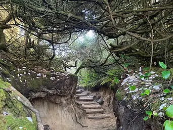
Hobbit Trail
A tunnel of salal and spruce that drops from the highway to a hidden beach.
Highway 101, north of Florence

Siuslaw Estuary Trail
A flat gravel path along the river, running east from the bridge past the tide flats where herons work the shallows.
Spruce Street at Highway 126, Florence

Woahink Lake Trail
A soft path through shore pine and rhododendron along the east shore, quiet enough that the lake stays glass until midday.
East Woahink Day Use, Canary Road

Darlingtonia Boardwalk
A short boardwalk over an eighteen-acre bog of cobra lilies.
Highway 101, north of Florence

Cleawox Lake Trail
A flat walk around the lake, past the old bathhouse and the sand slide.
Honeyman State Park

Siltcoos Lake Trail
A wooded loop of about four and a half miles that climbs to look down on the lake.
Siltcoos Lake Trailhead, Highway 101

John Dellenback Dunes Trail
A broad unmarked route across open sand out to the beach; bring a compass and water.
Highway 101, south of Reedsport

Umpqua Dunes Trail
A loop of about two and a half miles through the largest open sheet of sand on the coast.
Umpqua Dunes Day Use, off Highway 101

Sutton Creek Trail
A loop through the Heceta Dunes and along a slow creek, with the beach as a spur.
Sutton Beach Trailhead, Sutton Recreation Area

Eel Lake Trail
Three and a half miles around Eel Lake, most of it under big spruce and hemlock.
William M. Tugman State Park

Lake Marie Trail
A flat loop around Lake Marie, with the light and the dunes a few steps away.
Umpqua Lighthouse State Park

Cook's Ridge Trail #1370
Runs the ridge through old growth that survived the fires of the 1800s.
Cape Perpetua Trailhead, visitor center parking

Drift Creek Falls Trail
A mile and a half down to a waterfall and a suspension bridge above the gorge.
Siuslaw National Forest, near Lincoln City

Valley of the Giants
An ancient grove of Douglas fir along the river, reached by a short walk from the road.
Coast Range, near Falls City
Alder Dune Trail #1322
A one-mile loop through shore pine between Alder and Dune lakes, with a spur onto the sand.
Alder Dune Day Use, off Highway 101
Baker Beach Trail #1368
Half a mile one way to the beach; the trailhead also serves the Lily Lake and Berry Creek loops.
Baker Beach Campground
Lily Lake Trail #1397
Short loops through the deflation plain behind the foredune, where the wind keeps the trees low.
Baker Beach Trailhead
Battle Lake Trail #1302
Six tenths of a mile uphill to the lake; all of the climb is on the way in.
Nestucca River basin, near Beaver
Holman Vista Trail
A short path from the campground to a platform over the dunes and the surf.
Sutton Recreation Area
Waxmyrtle Trail
Follow the river out to the surf on the north side of the Siltcoos estuary.
Siltcoos River mouth
Tahkenitch Dunes Loop
A five-mile loop from the lake over open sand to the ocean and back through the pines.
Tahkenitch Lake Trailhead
Stagecoach Trail
A short forested route on the old stage road, open to hikers and horses.
Oregon Dunes National Recreation Area
Munsel Creek Trail
A paved path along the creek through town, the easy walk when the weather turns.
Quince Street to West Park Drive, Florence
Oregon Dunes Loop Trail #1334
Paved for the first half mile to an overlook, then down into open sand and out to the beach.
Oregon Dunes Day Use, near mile marker 201
Tahkenitch Creek Trail #1336
Follows the creek through shore pine to the beach, opening onto the dunes near the mouth.
Tahkenitch Landing Campground
Three Mile Lake North Trail #1338
Sand and forest to a landlocked lake behind the foredune.
Tahkenitch area, off Highway 101
Three Mile Lake South Trail #1356
The southern approach to Three Mile Lake, quieter and softer underfoot.
Tahkenitch area, off Highway 101
Chief Tsiltcoos Trail #1359
Winds up and down through coastal evergreen forest, with a bench over the lagoon.
Siltcoos, off Highway 101
Carter Dunes Trail #1384
Blue-striped posts lead from the trees over the deflation plain to the surf.
Carter Lake Campground, off Highway 101
Lagoon Loop Trail
A boardwalk loop through the wetland behind the dunes, good for birds and kids.
Lagoon Campground, Siltcoos
Hall Lake Loop
A short forest and sand loop to a small lake hidden in the dunes.
Eel Creek, off Highway 101
Giant Spruce Trail
Two miles round trip up Cape Creek to a spruce more than five hundred years old.
Cape Perpetua Visitor Center
Discovery Loop
A paved, wheelchair-accessible loop through the spruce with wayside panels.
Cape Perpetua Visitor Center
Gwynn Creek Trail #1371
Up along the creek through alder and spruce; the classic loop pairs it with Cook’s Ridge.
Cape Perpetua, Oregon Coast–Gwynn Creek trail junction
St. Perpetua Trail #1372
Switchbacks up the open south face to the highest viewpoint on the coast.
Cape Perpetua, from the visitor center
Cape Cove Trail
A short walk along the cove and under the highway, linking the churn to the center.
Cape Perpetua, Devil's Churn to the visitor center
804 Trail
Three quarters of a mile along the rock shore, paved and level, spray on a high sea.
Yachats, from the Adobe to Smelt Sands
Oregon Coast Trail: Yachats to Heceta Head
The long route through the cape, linking Yachats, Cook’s Chasm, and the dunes north.
Cape Perpetua section
Cape Mountain Trails
A small network of horse and foot loops through coastal forest, seldom crowded.
Cape Mountain, off Highway 101 near Sea Lion Caves
China Creek Falls Trail
A rough forest road and a short path to a falls on China Creek.
Siuslaw National Forest, east of Mapleton · Pin pending review
Longer entries
In-depth notes from the same ground.
